Videomety systems to measure waves from an image
Últimas noticias
Una mirada LGTBIQ+ al reino animal
Circular Economy in Action: Valorisation of By-products through Projects like PRIMA NEWFEED
Strategic Perspectives: Highlights from the Food4Future World Summit for Business Leaders
PEDRO LIRIA, IRATI EPELDE, ASIER NIETO researchers and ARITZ ABALIA PhD student in the area of Operational Oceanography
Knowing the wave conditions and being able to measure the height of the breaking wave is very important in order to establish the level of impact of waves on the coast during storms. However, this is not always an easy task.
To meet this need, within the framework of the Interreg POCTEFA MARLIT project, an algorithm has been developed to measure waves from the images obtained by the KOSTASystem videometry systems. Thus, through observation systems, we can improve and automate coastal risk management tools and characterise the impacts associated with storms.
Índice de contenidos
The advantages of videometry systems
A coastal videometry system consists of cameras installed on the coast that allow images to be captured and spatially referenced. Until now this systems have been used to monitor the morphological configuration of beaches, dunes, channels and bars, but in recent years significant advances have been made in the capacity of these systems to obtain reliable information on sea conditions and, in particular, the characterisation of waves on beaches.
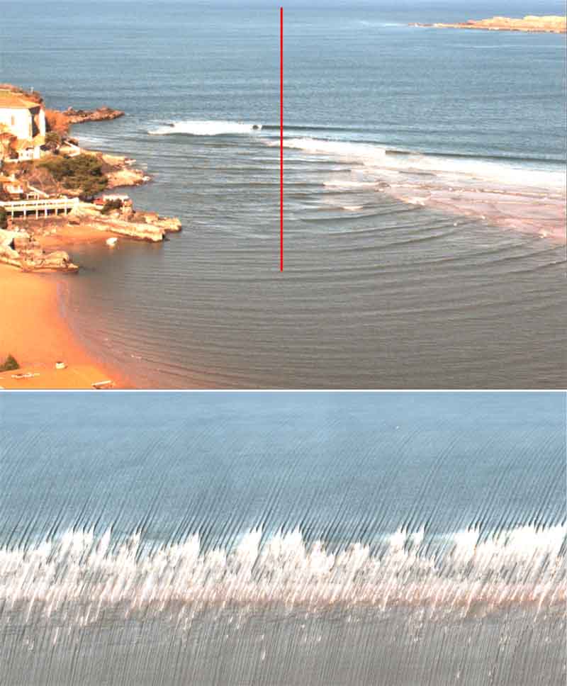
Coastal videometry systems process images that are captured at high frequency at regular intervals. The most common products derived from the processing of these images are the mean, the variance of the intensity values in each pixel or the accumulation of information from certain areas of the image. For wave characterisation, the existing approaches focus on the analysis of products generated by accumulation, known as timestack. These images are the result of the composition obtained from the successive accumulation of pixels located along a predefined line, during a given time interval and with a given frequency. Figure 1 shows an image taken by one of the cameras of the system installed in Mundaka, and the result of processing a timestack image from the profile highlighted by a red line. Thus, in these images, the rows of pixels represent the evolution of a pixel in the image over time, while the columns represent a transect of pixels at a given instant.
In this sense, within the framework of the MARLIT project, a computer development has been carried out to obtain different statistical and spectral wave parameters from the processing of the timestack images, among which are the wave period and the breaking and unbroken wave height.
MARLIT: “Medios de evaluación y Atenuación de los Riesgos costeros Locales debidos a Impactos de los Temporales”
AZTI lidera el proyecto MARLIT, una iniciativa transfronteriza que busca mejorar los mecanismos de predicción de riesgo de temporales en la costa vasca franco-española, y en la costa catalana, atendiendo a su evolución por el cambio climático. El proyecto tiene como objetivo principal mejorar el conocimiento y las herramientas disponibles para comprender los impactos de las tormentas actuales y futuras en la costa y, además, dar apoyo a las administraciones públicas en la gestión de riesgos costeros.
Además del centro tecnológico vasco, también participan la Universitat Politécnica de Catalunya, La Universidad de Pau, y el centro Rivages Protect como socios. Además, se cuenta con la colaboración de la Dirección de Atención de Emergencias y Meteorología (DAEM) del Gobierno Vasco, el Institut Cartogràfic i Geològic de Catalunya y la Comunidad de aglomeración del País Vasco.


