The sea is a very important element in our lives, especially for those of us who live near the coast and for those who depend directly on the resources that the sea offers us. For example, according to FAO data, 25% of the world’s population lives in coastal areas and this percentage is expected to increase to 50% by 2050. On the other hand, the Basque Country is a society that exemplifies this trend: 60% of the population lives less than 5 km from the coast and, consequently, our economy and our climate are strongly influenced by the sea.
In this sense, having the possibility of measuring its behavior and changes is key to ensure optimal management of these resources, to have adequate prevention plans for emergencies, such as spills or extreme events, and also, and I would almost say above all, to understand it better. Knowledge of the sea and its physical, biological and biogeochemical processes is the best tool for combating the various problems that threaten it, from problems of pollution by hydrocarbons, plastics and loss of biodiversity, to those related to climate change.
How is it done?
There has always been observation of the sea, one could almost say that it is part of the idiosyncrasy of the coastal towns, from observing the tides for shellfishing or the waves to avoid the risks of storms and gales, etc.
Ocean monitoring (understood as a routine and continuous measurement) has been done for decades on a global scale thanks to satellites and the oceanographic sensors installed on them, which provide global data on temperature, surface salinity, density currents, wind over the sea surface… the main limitation of these satellite data is that they have a limited resolution in space and also that many of these measurements are limited to the ocean surface layer. There are international networks dedicated to the observation of deeper layers, for example with autonomous platforms such as ARGO buoys or gliders, but they are still quite punctual… These aspects make them less useful in the coastal strip, where ocean variability occurs at smaller scales and strong vertical gradients are observed, and hence the relevant role of coastal observatories today.
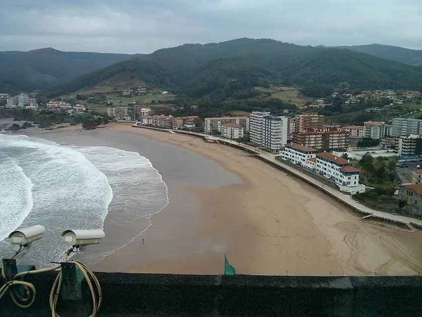
And it is precisely here where it is necessary to highlight the efforts made by the Department of Emergency Attention and Meteorology of the Basque Government and Euskalmet for the development and maintenance of the system of ocean-meteorological measurements of the Basque coast, and the system of Operational Oceanography EUSKOOS. EUSKOOS is an operational coastal observation system that brings together several systems for measuring different aspects of the ocean: its temperature, salinity, currents and variability. It consists of a network of coastal stations, fixed or moored buoys, high-resolution cameras and a high-frequency radar and numerical modeling system. EUSKOOS also centralizes the maintenance and improvement operations of all these systems and controls the quality and public availability of the data on a website where they can be consulted and downloaded by sea users who are interested in them.
Is it an AZTI creation ? What do you use it for?
EUSKOOS is a system created by EUSKALMET and the Department of Emergency Attention and Meteorology of the Basque Government, with the collaboration of AZTI in the marine aspects and serves as a portal for users of the sea to have a place to consult the current state of the sea and beaches, current and swell forecasts in the coming hours… in addition to the information already offered on the Euskalmet portal. We also publish news about exceptional events recorded, or the improvement works carried out, as well as research articles, ongoing projects…
How long have you been monitoring the sea?
The Basque Country has a long tradition of sea observation. The Oceanographic Society of Gipuzkoa was founded in 1908, the Monte Igeldo Observatory is one of the oldest observatories in Spain, and has had an important marine orientation since its foundation. The Aquarium of Donostia-San Sebastian has been collecting sea temperature data since 1946. In AZTI, since the 80’s, different observation campaigns have been carried out routinely, covering different points of the coast and the Bay of Biscay.
EUSKOOS, which focuses on what we call operational observation, i.e. “live” or real time data collection, which is the terminology we use, began to take shape with the installation of the first coastal monitoring station in Pasaia in 2001. Then came other coastal stations; the slope buoys in front of Donosti and Bilbao in 2007; a high frequency surface current observation system based on radar technology in 2009 and since 2010 the system is completed with an extensive network of videometry covering various points of interest along the coast, generally beaches, ports or urban areas adjacent to wave protection structures. And also from the beginning with the development and improvement of different configurations of numerical models applied to our area.
In order to draw conclusions, it will take time to make comparisons, won’t it?
Indeed, in order to draw conclusions we need long time series. Without a time series of temperature data for several years in the area we would not be able to detect anomalous temperature or stratification situations, or the same with wave heights. It is also necessary to have a previous knowledge of the ocean, both to correctly design the measurement network and to be able to interpret the real-time measurements that the network offers us.
In addition, the current trend is towards the integration of observations, i.e. towards the combination of all the data obtained in the area, from different platforms, campaigns, models to simulate the most complete possible 3D view of the ocean.
For example, we have recently been working on combining radar data that give surface current maps with buoy data that give us point current data at different depths, in order to obtain current maps at different depths and which are key if we want to study the transport of fish eggs or larvae, which occurs at a few tens of meters depth.
We are also working on the integration of disciplines, that is to say, in addition to trying to have physical data in real time, which is the main objective of EUSKOOS, at this time we think it is important to bet on the installation of new sensors that allow us to have continuous measurements of biological or biogeochemical variables and better understand how the coastal ecosystem responds to changes in current, wave or mixing conditions.
Do you share data with other centers?
Yes, at the moment several of the EUSKOOS systems are sending data both in real time and historical data to the large European data exchange programs such as Copernicus or EMODNET. These programs are in charge of compiling observations both in the open sea and from coastal observatories in large open access databases that allow to increase the use of these data in research of oceanic processes at much larger spatial scales, and also their use for the improvement of oceanic prediction models, a key element to obtain good forecasts of the state of the sea. It should also be noted that we are part of the European JERICO infrastructure, which aims to combine the efforts of the numerous observatories operating along the coasts of Europe to offer a unified service to scientific users of the data and of this type of facilities, and in general to end users of the information and services that can be derived from these data.
And in these times of monitoring, has the situation of the sea changed, its quality, its swell…?
The sea is naturally changing, and changes occur within time windows of different lengths, from a few hours (as in the case of the tide) to the climatic level.
Most of the EUSKOOS data series are relatively young for climate studies, although they are beginning to form a good basis.
As for the maps of surface currents, which are my specialty, the big changes in the data series we have are seasonal, i.e. there is a very strong polarization of summer and winter currents, which means that there are specific periods (late spring and summer) that seem to be more favorable to the accumulation of pollutants in coastal areas, although with many differences in different years, without any remarkable longer-term trend.
In any case, knowing the natural variability and better understanding the ocean-atmosphere interaction and its impact on the climate is key to have a good portrait of the current situation and to be able to reproduce it in the models, and this is what the EUSKOOS data are for, among other things. The observations help to increase the reliability of the models and for example to reduce the uncertainty in predicting future scenarios. The comparison of existing climate models with operational data is very important in this respect. It is not all about measuring, waiting and trend analysis.
The availability of sea level data, for example since 1840 at Brest, has allowed us to assess the impact of industrialization on sea level rise (mostly caused by rising ocean temperatures).
We have come a long way in understanding, including the effect that processes such as the Pacific “El Niño/Niña” may have on our climate.
Climate change forecasts have an impact on aspects such as the tropicalization of the climate of our latitudes; the increase in sea temperatures, in addition to producing a rise in sea level, will mean that the species that now inhabit our latitudes will have to move further north to find conditions similar to those they now have in our waters; there are studies that suggest that the storms that produce strong waves on our coast may move their center somewhat further south, which would have an impact on the direction and height of the waves, etc. These issues and many others are currently lines of work, discussion and scientific development. Having good measurement and data and knowledge exchange networks will improve our ability to adapt to the climate of the future.
Is the monitoring constant or is there some sort of “campaigns” for this?
EUSKOOS works as I mentioned before, operationally or in real time and the monitoring of the variables covered by the EUSKOOS systems is continuous except when there are operational problems, either because the radar antenna is struck by lightning or because a camera stops working or because a buoy is accidentally pulled out of place or is knocked off anchor due to a major storm. Maintenance of observing systems involves routine campaigns, for example, to retrieve data, maintain sensors and replace batteries on slope buoys (which are several miles offshore) or for periodic calibration of radar antennas. We have also conducted campaigns with gliders, drifting buoys, one recently in collaboration with IFREMER on board an oceanographic vessel in the area covered by the radar, focused on the more detailed study of the physical aspects of the currents and the interactions between the current and the biological activity or the subject of plastics. And well it must be said that in AZTI, apart from real-time monitoring, many efforts are made by other research teams, such as long-term monitoring of water quality along our coasts or other key variables for climate change studies, or evaluation of fish stocks. And from the Marine Technologies group, we have
Can these ways of monitoring, of control, serve to prevent… disasters or any kind of problems that may come from the sea?
Yes, definitely. In fact, apart from mitigation measures to reduce the pressure we humans exert on the sea, I can think of no other way of prevention than to have a detailed knowledge of the sea, how it behaves, how it changes. There are several examples of the use of EUSKOOS data for this purpose. For example, the data has allowed us to face challenges such as the Prestige spills in 2002-2003 or the Grande America in 2019, search and rescue of people at sea, the presence of jellyfish on beaches, studies on the presence of plastics and floating garbage in the sea, etc.
This information has also been used to draw up the plan of the Euskadi Special Emergency Plan for seashore pollution, ITSASERTZA, or the development of an operational coastal risk index for storm situations with a high probability of flooding and erosion on beaches, ports and promenades or other coastal infrastructures.
And, although somewhat less directly related to the ocean, last summer the videometry network, through KOSTASYSTEM was especially popular for its usefulness in regulating beach gauging to meet social distance requirements arising from the health crisis.