Operational oceanography tools to reduce the impact of storms on the coastline
Últimas noticias
Una mirada LGTBIQ+ al reino animal
Circular Economy in Action: Valorisation of By-products through Projects like PRIMA NEWFEED
Strategic Perspectives: Highlights from the Food4Future World Summit for Business Leaders
PEDRO LIRIA, researcher at Operational Oceanography
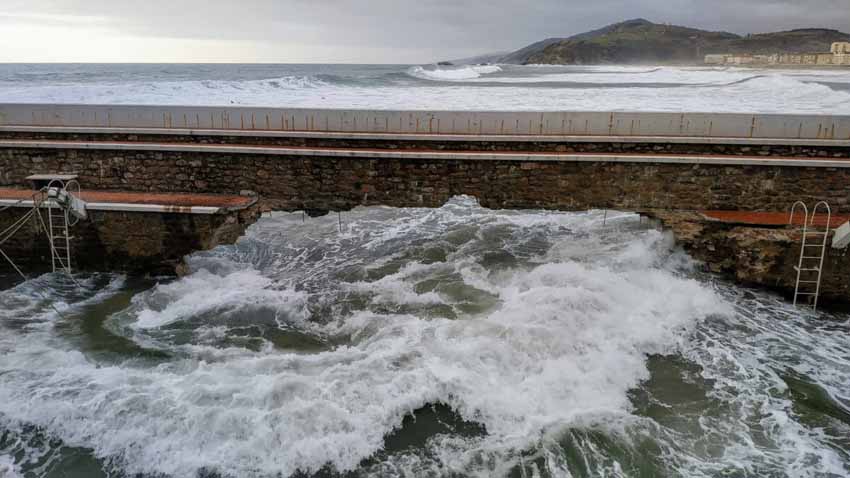
It is 10 years since the series of storms that shook the entire European Atlantic coast and caused serious damages. Donostia, Zarautz, Bermeo, Bakio and Elantxobe were especially hard hit. In the early months of 2014 occurred the “perfect storm”: in three months there were up to 8 storms of an unusual magnitude, with the consequent pressure on the coast, to which exceptional situations had to be added, such as the one that took place in the early hours of 2 February, when the peak of one of these storms coincided with a very high tide, considerably increasing the damage.
Although the winter of 2014 was exceptional, it should not be forgotten that climate change, and in particular the rise in sea level, considerably increases the vulnerability of the coast to storms. Although we can indeed do nothing to prevent these events from occurring, it is important to highlight that we have increasingly better means of operational oceanography to deal with them and reduce their consequences.
Índice de contenidos
KOSTASystem: information on coastal processes from images
To address the challenges of coastal erosion, it is crucial to consider the various spatial and temporal scales that define coastal dynamics. In recent years, coastal videometry systems have undergone a significant deployment due, on the one hand, to the various applications they allow and their wide spatial and temporal coverage, and on the other, to their low cost and their autonomous measurement method.
In this context, in AZTI’s operational oceanography area, we have developed a line of work in coastal videometry called KOSTASystem, which makes it possible to measure and describe complex physical processes, as well as the effects of human activities on the coastal strip.
With more than 30 active stations, KOSTASystem is mainly used for:
- Monitoring coastal morphology: shoreline, intertidal topography, sand bar systems and rip currents.
- Monitor the impact of waves on the coast.
- Generate information on the uses of the coastal strip.
Improving storm risk forecasting mechanisms
AZTI, since 2014, to reduce the effects of storms, especially in coastal towns, has developed projects focused on improving monitoring tools and early warning systems against storms. The latest of these projects was MARLIT, a cross-border initiative that sought to improve storm risk prediction mechanisms on the French-Spanish Basque coast and the Catalan coast, also taking into account their evolution due to climate change.
This project has implemented, in collaboration with the Basque Government’s Directorate of Emergency Services and Meteorology (DAEM) and Euskalmet, innovative monitoring systems, such as autonomous topographic observations and new videometric tools, as well as state-of-the-art modelling of wave propagation to predict the impact of storms.
MARLIT has also developed an algorithm for measuring waves or automatically detecting the overtopping of a dyke or the flooding of a promenade from the images obtained by the KOSTASystem videometry systems. These observation systems enable us to improve and automate coastal risk management tools and to characterise the impacts associated with storms.


